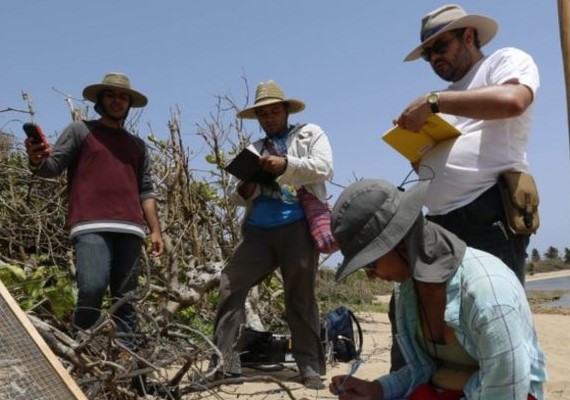
A group of scientists is hurrying to document ancient ruins on the U.S. territory of Puerto Rico. The sites, along Puerto Rico’s coast, date back a few thousand years. The scientists are working as fast as they can before rising sea levels destroy a large part of the island’s history. Scientists hope to use the three-dimensional (3D) images they have taken to help identify which sites are most at-risk to natural disasters and other dangers. Falko Kuester is director of the Cultural Heritage Engineering Initiative at the University of California, San Diego. He said, “A big part of what we’re working on is to make the invisible visible and make sure it stays in our memory.” The university, known as UCSD, is involved in the research project. Also involved are its Scripps Institution of Oceanography and Para la Naturaleza, an environmental group based in Puerto Rico. The work started in August 2017. Scientists first explored a large stretch of land along Puerto Rico’s north coast. That area includes a ceremonial center used by the Taino Indians about 2,000 years ago, said Isabel Rivera Collazo. Rivera is an environmental archaeologist at UCSD and directing the project. She said the scientists found what appears to be a large settlement just east of the ceremonial site. It was discovered with help from drone aircraft and other technology, including 3D images. She added that scientists were also able to map out the shape of the ceremonial site.
Title: Puerto Rico’s Coastal Heritage
Content: <div id='article-page'><div id='article-content' data-media-url='//news-app-staging.s3.amazonaws.com' data-base-url='//news-app-staging.herokuapp.com' data-sound-name='https://news-app-production.s3.amazonaws.com/articles/4627/B.wav' data-capture-url='//staging.analytics.lingraphica.com/events/capture_news' data-article-title='Puerto Ricos Coastal Heritage' data-article-id='5154'><script src='//news-app-staging.herokuapp.com/javascripts/getscripts.js'></script><link rel='stylesheet' href='//news-app-staging.herokuapp.com/stylesheets/article.css' type='text/css' /><div class='article'><p><span data-start-time='0' data-end-time='8354'>A group of scientists is hurrying to document ancient ruins on the U.S. territory of Puerto Rico.</span> <span data-start-time='8354' data-end-time='15646'>The sites, along Puerto Rico’s coast, date back a few thousand years.</span> <span data-start-time='15646' data-end-time='26875'>The scientists are working as fast as they can before rising sea levels destroy a large part of the island’s history.</span> <span data-start-time='26875' data-end-time='42438'>Scientists hope to use the three-dimensional (3D) images they have taken to help identify which sites are most at-risk to natural disasters and other dangers.</span> <span data-start-time='42438' data-end-time='52813'>Falko Kuester is director of the Cultural Heritage Engineering Initiative at the University of California, San Diego.</span> <span data-start-time='52813' data-end-time='63917'>He said, “A big part of what we’re working on is to make the invisible visible and make sure it stays in our memory.”</span> <span data-start-time='63917' data-end-time='71604'>The university, known as UCSD, is involved in the research project.</span> <span data-start-time='71604' data-end-time='83375'>Also involved are its Scripps Institution of Oceanography and Para la Naturaleza, an environmental group based in Puerto Rico.</span> <span data-start-time='83375' data-end-time='88438'>The work started in August 2017.</span> <span data-start-time='88438' data-end-time='96979'>Scientists first explored a large stretch of land along Puerto Rico’s north coast.</span> <span data-start-time='96979' data-end-time='109042'>That area includes a ceremonial center used by the Taino Indians about 2,000 years ago, said Isabel Rivera Collazo.</span> <span data-start-time='109042' data-end-time='117146'>Rivera is an environmental archaeologist at UCSD and directing the project.</span> <span data-start-time='117146' data-end-time='126500'>She said the scientists found what appears to be a large settlement just east of the ceremonial site.</span> <span data-start-time='126500' data-end-time='135833'> It was discovered with help from drone aircraft and other technology, including 3D images.</span> <span data-start-time='135833' data-end-time='144375'> She added that scientists were also able to map out the shape of the ceremonial site.</span> </p></div><div class='control-buttons-sticky' style='display:none;'><div class='control-buttons'><button title='Back' class='back' disabled='disabled'></button><button title='Play' class='play' disabled='disabled'></button><button title='Pause' class='pause' style='display:none;'></button><button title='Forward' class='forward' disabled='disabled'></button><button class='finished-reading' style='display:none;'>Done</button></div></div></div><div id='article-media'><div id='media-image'><img src='https://news-app-production.s3.amazonaws.com/articles/4627/B.jpg'/></div></div><div id='question-content' style='display:none;'><div class='vocabulary_question question-container' data-question-id=16168 data-hint-location='26875' style='display:none;'><div class='question' data-sound-name='https://news-app-production.s3.amazonaws.com/articles/4627/what_does_3d_stand_for.wav'>What does 3D stand for?</div><div class='choices' data-correct-choice=' three dimensional'><div class='choice' data-sound-name='https://news-app-production.s3.amazonaws.com/articles/4627/_three_dimensional.wav'><span> three dimensional</span></div><div class='choice' data-sound-name='https://news-app-production.s3.amazonaws.com/articles/4627/three_degrees.wav'><span>three degrees</span></div><div class='choice' data-sound-name='https://news-app-production.s3.amazonaws.com/articles/4627/thermal_imaging.wav'><span>thermal imaging</span></div><div class='choice' data-sound-name='https://news-app-production.s3.amazonaws.com/articles/4627/those_dudes.wav'><span>those dudes</span></div></div></div><div class='multiple_choice_question question-container' data-question-id=16169 data-hint-location='15646' style='display:none;'><div class='question' data-sound-name='https://news-app-production.s3.amazonaws.com/articles/4627/why_are_the_historical_sites_in_danger.wav'>Why are the historical sites in danger?</div><div class='choices' data-correct-choice='because of rising sea levels'><div class='choice' data-sound-name='https://news-app-production.s3.amazonaws.com/articles/4627/because_of_rising_sea_levels.wav'><span>because of rising sea levels</span></div><div class='choice' data-sound-name='https://news-app-production.s3.amazonaws.com/articles/4627/because_of_boycotts.wav'><span>because of boycotts</span></div><div class='choice' data-sound-name='https://news-app-production.s3.amazonaws.com/articles/4627/because_of_lack_of_interest.wav'><span>because of lack of interest</span></div><div class='choice' data-sound-name='https://news-app-production.s3.amazonaws.com/articles/4627/because_of_protests.wav'><span>because of protests</span></div></div></div><div class='sentence_completion_question question-container' data-question-id=16170 data-hint-location='0' style='display:none;'><div class='question' data-sound-name='https://news-app-production.s3.amazonaws.com/articles/4627/scientists_are_hurrying_to_document_ancient_ruins_in__blank_.wav'>Scientists are hurrying to document ancient ruins in <span class='blank'>Puerto Rico</span>.</div><div class='choices' data-correct-choice='Puerto Rico'><div class='choice' data-sound-name='https://news-app-production.s3.amazonaws.com/articles/4627/puerto_rico.wav'><span>Puerto Rico</span></div><div class='choice' data-sound-name='https://news-app-production.s3.amazonaws.com/articles/4627/saint_croix.wav'><span>Saint Croix</span></div><div class='choice' data-sound-name='https://news-app-production.s3.amazonaws.com/articles/4627/bahamas.wav'><span>Bahamas</span></div><div class='choice' data-sound-name='https://news-app-production.s3.amazonaws.com/articles/4627/bermuda.wav'><span>Bermuda</span></div></div></div><div class='question-buttons'><button class='skip-button'></button><button class='hint-button'></button><button class='speak-button'></button></div></div></div>
Sound Name: https://news-app-production.s3.amazonaws.com/articles/4627/B.wav
Preview